

Where Does the Great Salt Lake Water Come From? And Where Is It Going?
The Great Lake Watch — Article 2 (Posted April 4, 2026)
THE GREAT LAKE WATCH An educational series on the Great Salt Lake — what it is, how it works, and why it matters to everyone on the Wasatch Front.
The lake has no drain. There is no river leaving it, no channel carrying water away to the sea. The Great Salt Lake sits at the bottom of a closed basin — a terminal lake with no outlet, so the only way water can leave is through evaporation. Whatever flows in, stays in — until the sun takes it.
That single fact explains almost everything about the lake's health. Because if no water is leaving except through evaporation, then the lake's level is entirely controlled by how much water is arriving. And understanding that is where this article begins.
How the Water Gets There
Water enters the Great Salt Lake through direct precipitation, the Bear, Weber, and Jordan Rivers, and internal springs. The lake's watershed covers more than 21,000 square miles.
Of those sources, the rivers carry the load. The Bear, Weber, and Jordan Rivers empty into the eastern part of the lake and together supply around 70 percent of the water input. The Bear River alone supplies nearly 40 percent of all the lake's total water input — and roughly 60 percent of the river-sourced inflow specifically. Direct precipitation on the lake's surface accounts for roughly 30 percent, with groundwater and intermittent streams from the West Desert making up the rest.
Of the surface water contributions to the lake, the Bear River provides 58 percent, the Weber River provides 15 percent, and the Jordan River provides 22 percent, with the remainder from smaller streams.
The Bear River begins in the Uinta Mountains, winds north through Wyoming and Idaho, and curves back into Utah — traveling nearly 500 miles before finally emptying into Bear River Bay on the lake's northeastern shore. Audubon's director of the Saline Lakes Program has called it "such a critical life-giving source for people and wildlife — all along its path — and ultimately as the greatest source of water for Great Salt Lake."
All of this water carries dissolved minerals. The lake's three major tributaries together deposit around 1.1 million tons of minerals in the lake per year. Since the lake has no outlet besides evaporation, these minerals accumulate and give the lake its high salinity — far saltier than seawater.
That is the system as nature designed it. Now here is where it has broken down.
Why the Lake Is Receding
The science on this question has become clear over the past decade. The primary cause of the Great Salt Lake's decline is not a mystery of climate, and it is not an act of nature. It is water diversion by people.
A landmark study published in the journal Nature Geoscience by Wayne Wurtsbaugh, a limnologist at Utah State University, tested whether climate cycles were responsible for the lake's long decline. His team recreated the climate around the Great Salt Lake for 170 years using historical precipitation records, stream level records, and tree ring data. Those records showed that precipitation and temperature patterns had hardly fluctuated during the period, meaning the amount of water flowing into the lake from nearby streams is likely the same today as it was in 1847.
The water was there. It was just being stopped before it reached the lake.
Every year, people living in the region divert 3.3 trillion liters of water — not from the lake itself, but from the handful of streams feeding it. With climate staying relatively stable, the team concluded that humans are triggering the decline by consuming streamwater before it replenishes the lake.
Subsequent research has confirmed and sharpened that finding. Researchers estimate that 75 percent of the lake's water loss can be explained by human water uses, while about 25 percent can be attributed to a long-running drought. Approximately 62 percent of river water heading toward the Great Salt Lake gets diverted for human use. Agricultural activities are the primary culprit, accounting for nearly three-quarters of the water diverted — and nearly 80 percent of that agricultural water is used to irrigate alfalfa and hay crops to feed livestock.
Climate change is a real and measurable factor, but it is secondary. Current estimates attribute about 9 percent of the lake's decline to climate change. A 2024 study published in Geophysical Research Letters found that shrinking streamflows accounted for about two-thirds of the lake's total volume drop, but increased evaporation from rising temperatures was necessary for the lake to reach its record low.
Has the Decline Been Speeding Up?
Yes — and measurably so in recent years.
Water diversions and overconsumption upstream have accounted for 11 feet of lost elevation since the lake was first measured in the 19th century. That loss didn't happen at a steady rate. An extremely uncommon wet period in the 1980s temporarily refilled the lake, but since peaking in 1987 it has been in steady decline. Over the last several years, the lake received less than a third of its natural streamflow because of excessive water diversions.
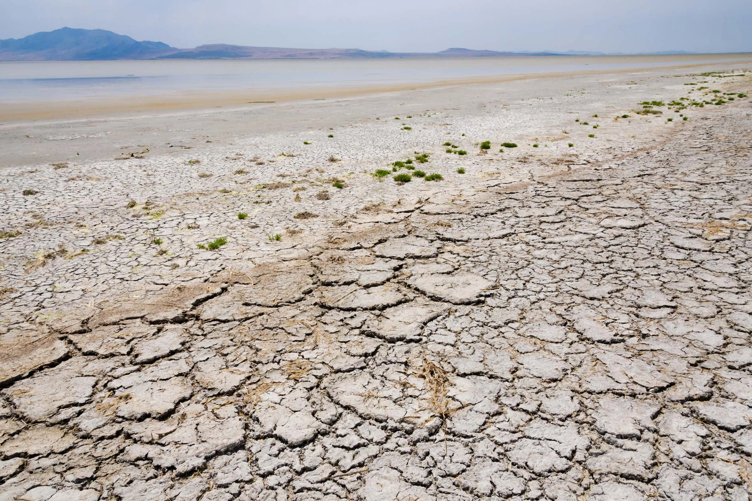
The last decade has been particularly severe. The lake's drop accelerated since 2020, with an average deficit of 1.2 million acre-feet per year. In November 2022, the South Arm reached a new record low elevation of 4,188.5 feet above sea level.
A compounding factor has emerged as the lake shrinks: the exposed lakebed itself makes the problem worse. Dust storms from the shrinking lakebed and reduced snowpack reinforce each other, likely further accelerating the lake's decline if upstream water diversions continue. Less snow means less spring runoff. Less runoff means more lakebed exposed. More lakebed means more dust reaching the mountains. And more dust on the snowpack means it melts sooner — before the soil and reservoirs can capture it.
As of April 3, 2026, the lake's South Arm sits at 4,192.3 feet above sea level — still well below where scientists say it needs to be.
What Scientists Say Needs to Happen
Researchers have been specific. Several credible scientific studies estimate that the minimum healthy level for the Great Salt Lake is 4,198 feet above sea level. The Great Salt Lake Commissioner's Strategic Plan establishes a target elevation range of 4,198 to 4,205 feet — a range that balances the wide variety of ecological, economic, and recreational interests detailed in the lake's Elevation Matrix.
That doesn't sound like much of a gap. It's only about six feet. But because the lake is so wide and shallow — generally less than 15 feet deep at median water level, with a maximum depth of 35 feet — each foot of elevation change translates to an enormous shift in surface area. At the 2022 record low, the lake's surface area was approximately 888 square miles. At an average elevation of 4,200 feet, the surface area would be roughly 1,700 square miles.
Reaching 4,198 feet will require a substantial, sustained change in how much water reaches the lake. BYU professor Ben Abbott, director of the lake advocacy organization Grow the Flow, estimated that the lake currently holds about 8.3 million acre-feet of water, and that reaching a healthy level would require adding approximately 5 million additional acre-feet.
Researchers at BYU and other institutions have called for an emergency streamflow requirement of at least 2.5 million acre-feet per year until the lake reaches its minimum healthy elevation of 4,198 feet.
Governor Spencer Cox announced a goal in 2025 to reach that level by 2034 — timed to coincide with the Salt Lake City Olympics. Utah State University professor David Tarboton, a member of the Great Salt Lake Strike Team, said reaching that goal in nine to ten years would require an additional 800,000 acre-feet of inflow per year — roughly a 40 percent increase in the amount currently reaching the lake.
Between 2021 and 2025, nearly 400,000 acre-feet of water were dedicated and delivered to the lake through water leasing, conservation programs, and large-scale invasive plant removal projects. Progress, but still a fraction of what is needed.
The Strike Team's long-range projections are sobering: sustained additional inflow of 800,000 acre-feet per year would be necessary to return the lake to healthy levels by 2055 under a 30-year timeline.
Where does that water come from? Scientists point to several overlapping strategies: voluntary water leasing programs that compensate farmers for leaving water in the rivers, significant reductions in outdoor lawn irrigation on the Wasatch Front, and what researchers call "water shepherding" — making sure that water conserved upstream actually flows to the lake rather than being redirected elsewhere. Researchers also warn that proposed Bear River Development projects, which would send a large share of Bear River water into new canals for municipal use, must be reconsidered — such development could lower the lake several additional feet in elevation.
The Great Salt Lake Strike Team's 2025 report emphasized that shared responsibility — across agriculture, municipal water users, industry, and individual households — is one of the key lessons of recent years. Outdoor watering accounted for 97 percent of all municipal and industrial water consumption in 2024, with approximately 408,500 acre-feet used on residential lawns.
The Number to Remember
4,198 feet. That is the minimum elevation scientists define as a healthy Great Salt Lake. As of early April 2026, the lake sits at 4,192.3 feet — nearly six feet below that threshold. Every foot matters. Every acre-foot of water that reaches the lake instead of evaporating from a lawn or an irrigation ditch is part of the math.
The lake is not gone. But the window for getting it back to a healthy level is narrowing, and the science is no longer uncertain about what that will require.
🔜 Next in The Great Lake Watch: Who controls the water? A look at prior appropriation water law in Utah — the legal framework that governs who has the right to take water from the Bear, Weber, and Jordan Rivers, and what recent legislative changes mean for the lake.
Sources
Utah Geological Survey — Commonly Asked Questions About Utah's Great Salt Lake (geology.utah.gov)
Utah Division of Wildlife Resources — Great Salt Lake Water Levels (wildlife.utah.gov)
USGS Great Salt Lake Hydro Mapper (webapps.usgs.gov/gsl)
Friends of Great Salt Lake — About the Lake (fogsl.org)
Salt Lake County Watershed Program — Amazing Great Salt Lake (saltlakecounty.gov)
Wurtsbaugh, W.A., et al. — Decline of the world's saline lakes, Nature Geoscience, 2017 (via science.org)
Abbott, B.W., et al. — Emergency measures needed to rescue Great Salt Lake from ongoing collapse, BYU, 2023 (pws.byu.edu/great-salt-lake)
Bigalke, S., et al. — Geophysical Research Letters, 2024 (via earth.com)
USU Extension — Agriculture Water Use and Economic Value in the Great Salt Lake Basin (extension.usu.edu)
Ballard Brief — The Aridification of the Great Salt Lake, BYU (ballardbrief.byu.edu)
University of Utah — A Roadmap for Rescuing the Great Salt Lake, 2024 (attheu.utah.edu)
University of Utah — Great Salt Lake Levels Remain Low, January 2026 (attheu.utah.edu)
Utah News Dispatch — What's It Going to Take to Get to 4198?, October 2025
KSL.com — 5 Lessons Learned About the Great Salt Lake in 2025, January 2026
Earthjustice — State of Utah Releases Inadequate Plan to Save the Great Salt Lake, 2024
Utah Rivers Council — Protecting the Great Salt Lake (utahrivers.org)
USGS Saltair Gage 10010000 — Current lake elevation data, April 3, 2026
This article was produced with AI assistance. All facts, statistics, and sourced claims were verified against primary sources listed above. This is the editorial standard for The Great Lake Watch.